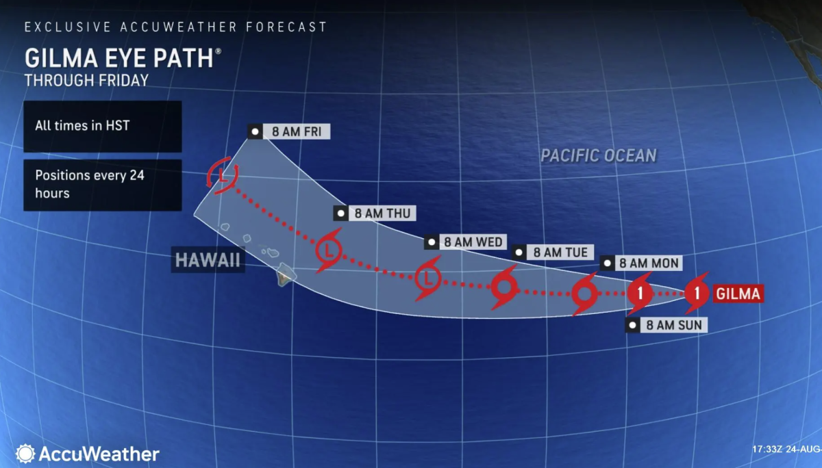
The Hawaiian Islands are on high alert as two tropical cyclones, Hone and Gilma, approach the archipelago in quick succession, potentially delivering a rare one-two punch of severe weather to the state.
Tropical Storm Hone is expected to pass just south of the Big Island later this weekend, while Hurricane Gilma looms on the horizon, potentially threatening the island chain by midweek. The National Weather Service (NWS) in Honolulu has issued warnings for high winds, heavy rainfall, and dangerous surf conditions across much of the state.
As of Friday afternoon, Hone was located about 620 miles east-southeast of Hilo. A tropical storm warning is in place for the waters surrounding Hawaii, with a tropical storm watch for the Big Island and a small craft advisory for the other islands. Maximum sustained wind speeds for Hone were measured at 46 mph, according to the National Hurricane Center (NHC).

The NWS expects Hone to gradually strengthen and continue moving toward the west over the next couple of days. “The latest forecast track brings the center of Hone near or south of the Big Island from Saturday night into Sunday morning as a strong tropical storm,” the NWS said in a recent update. “Hone will then strengthen to a Hurricane late Sunday into Monday as it passes south of Kauai and Oahu.”
NWS meteorologist John Bravender previously told Newsweek that rain will be a threat for the Big Island, particularly for the east and southeast sides of the island. However, there is little threat of storm surge flooding, although flooding could occur from heavy rain.
The NWS warns that hazardous winds could damage infrastructure like porches, awnings, carports, or sheds. Winds also could snap large tree limbs, with some trees succumbing to the storm. Debris might make roads impassable, and there could be scattered power and communication outages.
Newsweek contacted the NWS via email on Saturday for further comment.
Most spaghetti models, or computer models illustrating potential storm paths, show Hone passing south of Hawaii as it approaches the island. However, some models indicate the possibility of a direct impact.
Adding to the complexity of the situation is the approach of Hurricane Gilma, which formed in the Pacific on Wednesday and is the ocean’s second hurricane of the season. While Gilma is expected to weaken considerably as it nears Hawaii, its exact track and intensity remain uncertain.
The Pacific Hurricane Season has seen heightened activity this year, with seven named storms already. This comes in contrast to the Atlantic Hurricane Season, which typically produces storms that more frequently impact the continental United States.
AccuWeather meteorologists expect both Hone and Gilma to have some impact on the islands. “The strength of these wind gusts will be highly dependent on the exact track of the storm,” Lead Hurricane Expert Alex DaSilva explained on AccuWeather’s website.
“Wind gusts of 40-60 mph are expected mainly across the southernmost islands with higher gusts of 60-80 mph possible across far southern portions of the Big Island with an AccuWeather Local StormMax of 100 mph.”
Heavy rain is also expected across portions of the Hawaiian Islands this weekend into the early part of the next week. “A general 1-2 inches of rain can occur across the islands with higher amounts of 2-4 inches on the Big Island and Maui, and even 8-16 inches on the windward side of the mountains of the Big Island with an AccuWeather Local StormMax of 20 inches,” DaSilva said on AccuWeather’s website.
The combination of both tropical cyclones will likely bring an extended period of rough seas and surf to the islands, posing dangers to boarders, swimmers, and small craft.
Back-to-back tropical cyclone impacts are extremely rare in Hawaii. Two named storms have not passed within 300 miles of the main islands of Hawaii within a week since 1992. In September of that year, Hurricane Iniki was followed three days later by a direct strike from Tropical Depression Orlene.

As Hone approaches and Gilma looms on the horizon, Hawaii’s residents and visitors are being urged to stay vigilant. The coming days will test Hawaii’s resilience and emergency preparedness as the state faces this rare double threat.


